
Is It Safe for Pilots to Sleep in the Cockpit?
If I tell you that, before, pilots did sleep in the cockpit, and it is safer rather than riskier for pilots as well as passengers, it might
Aviation is a field that has various technical aspects in store for you. Have you ever wondered how it is used to measure the distance travelled by an aircraft? It is a nautical mile. While most land-based activities depend on kilometres or miles, the aviation industry makes use of nautical miles. But what is a nautical mile and why has it become the gold standard in the sky? We will discuss this and much more in this blog.
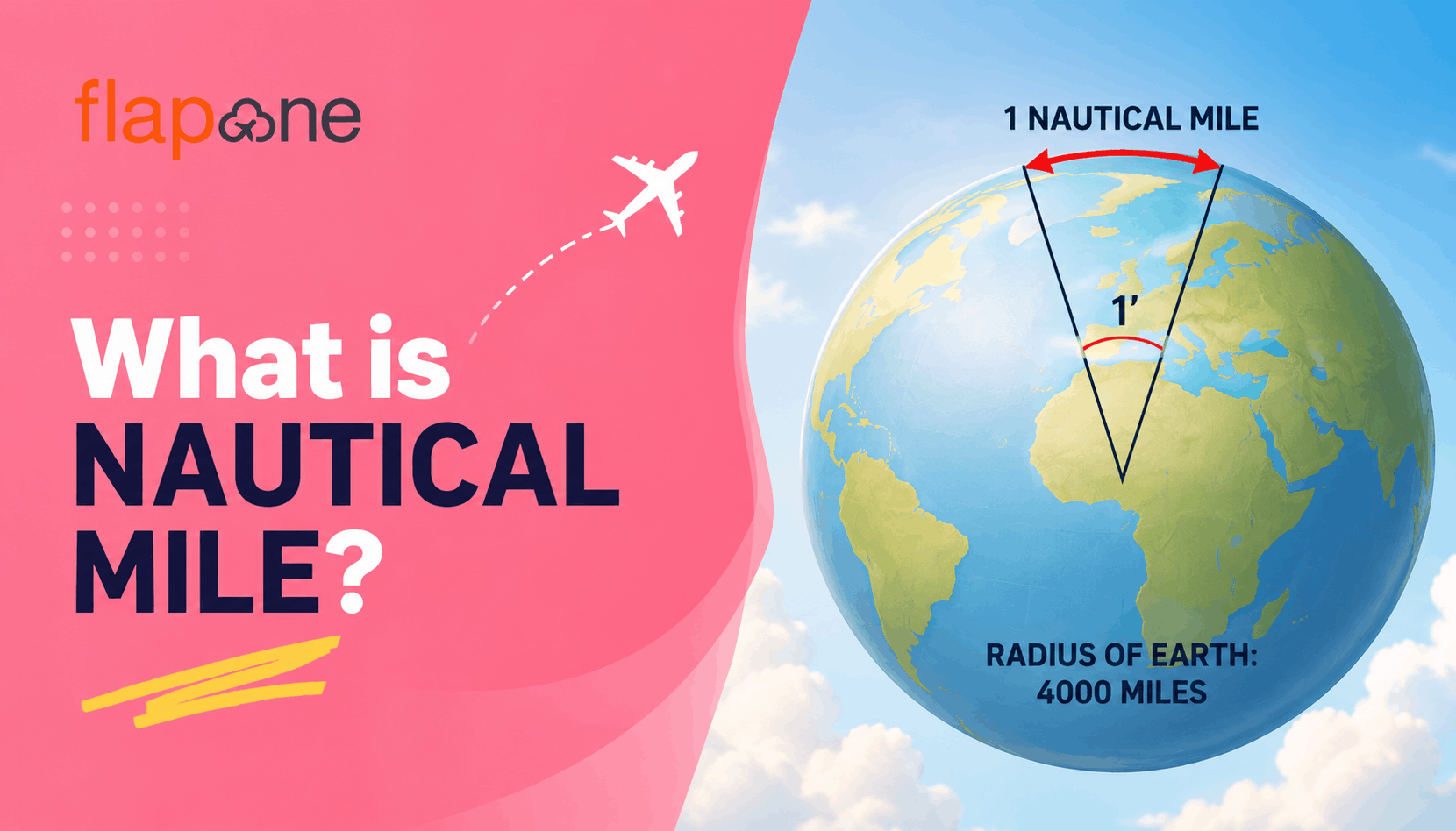
To understand this concept, we need to delve into the fundamentals of the Earth’s geography. The Earth has longitudes and latitudes, with the latter running horizontally and the former running vertically.
Aviation authorities have adopted the nautical mile as the standard measurement unit. Knowledge of the nautical mile is vital for pilots and navigators to guarantee precise position reporting and safe flight operations. The detailed calculation of flight distances is vital for fuel planning, navigation and adhering to ATC instructions.
Pilots use a combination of navigation aids, including Global Positioning System, VHF Omnidirectional Range and Distance Measuring Equipment, to compute distances in nautical miles.
These navigation aids provide precise position information, enabling accurate distance measurement.
Throughout the flight, pilots use navigation systems to track their position. These systems display the remaining nautical miles to the next waypoint, helping pilots assess the time and fuel required for the next flight leg.
The nautical mile is important in air traffic control (ATC). Air traffic controllers use radars to monitor aircraft positions and guarantee safe separation. When offering instructions to pilots, controllers refer to nautical miles to transport precise clearance limits or vector aircraft onto the accurate flight path.
There are various practical reasons why aviation uses nautical miles. The most important of these is navigation precision. Since nautical miles are associated with the Earth’s geometry, they allow for thorough calculations when plotting courses globally. This precision is crucial for GPS, which relies on standardized units of measurement to offer precise location data.
Moreover, the usage of nautical miles in international aviation guarantees consistency and standardization. Aircraft regularly cross several nations and time zones. A nautical mile allows pilots, air traffic controllers and other aviation professionals to communicate effectively. This consistency is important for maintaining flight safety, particularly in congested airspaces.
Another facade is the association between distance and speed in aviation. Aircraft speed is measured in nautical miles. This simplifies the calculation of travel time and fuel requirements, thus enhancing the utility of the nautical mile in aviation.
The Boeing 737 depends on nautical miles for several aspects of flight planning and performance calculations.
Range and Endurance: These are the competencies to fly a certain distance and stay in the air. For the Boeing 737, these are expressed as nautical miles. For example, theBoeing 737 has a range of 2,935 nautical miles and an endurance of around 375 minutes. These figures can vary depending on the payload, wind and engine performance.
Performance Calculations: Nautical miles are different in various performance calculations for the Boeing 737. Take, for instance, takeoff and landing performance. Pilots need to regulate the essential runway length on the basis of the aircraft’s weight and conditions. This calculation utilizes performance charts that provide values in nautical miles. By inputting the aircraft’s weight and further parameters, the charts can offer the essential distances for takeoff and landing.
Navigation and Route Planning:Effective navigation and route planning are essential for every safe and efficient flight. Pilots carefully plan their journey by following designated waypoints, airways, and flight paths, with distances commonly measured in nautical miles (NM). This standardized unit helps ensure accurate navigation across different airspaces while maintaining safe separation from other aircraft. Throughout the flight, Air Traffic Controllers (ATCs) use nautical miles to issue precise routing, spacing, and approach instructions, enabling pilots to navigate confidently and ensuring smooth, organized, and safe air traffic operations.
The entire concept of nautical miles is here and all the pilots must understand. If you want to become a pilot, it is advisable to enroll in a pilot training institute. Flapone Aviation is one of the top training schools in India, and what makes it one of the best is the quality of the instructors, the use of all the latest technologies and last but not least, the fees charged is nothing, when you considered the standard of theoretical instruction and also the practical exposure of handling airplanes.
From selecting the right drone to finding a course, our team can guide you through every step of your drone journey.